TROPICAL STORM MARCO:
Mississipi river had a landfall when the Tropical Storm Marco hit the area. Though the storm was very strong in the beginning, it is now losing the severity and intensity it had at the start. According to current weather forecasters, the storm is not dangerous any more as it is becoming weak with each passing day.
National Hurricane Center’s Update on Marco:
The National Hurricane Center, one of the biggest weather forecasting forums recently gave an update on the storm Marco, saying that the storm is losing its speed and intensity of the wind as it is moving towards Southern Louisiana and is no more a tropical storm. They also reported that Marco is not dangerous any more as it has lost its organization and wind speed.
TROPICAL STORM LAURA GETTING STRONGER:
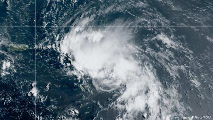
Meanwhile, storm Marco is losing its severity and intensity, Tropical Storm Laura is getting powerful with each passing day. According to the forecasters, this storm can turn into one of the biggest hurricanes ever, after Hurricane Rita, which happened in 2005, in the Gulf of Mexico and resulted in a lot of destruction and casualties.
Till now, Laura has attained about 35mph worth of wind speed which could be very destructive in so many ways. Laura’s nature is changing with each passing day like Storm Marco, the only difference is that Marco is losing its intensity and is becoming weaker with every day and is not dangerous anymore, while Tropical storm Laura is getting stronger and stronger every day.
It is predicted to create landfall in or near Southern Louisiana or at the East Texas Coastline. According to the weather forecast reporters, the storm could be of category two and would be one of the biggest hurricanes. It is suspected to hit these areas on Wednesday.
NEW ORLEANS, NATIONAL WEATHER SERVICE ALERT THE RESIDENTS ABOUT STORM LAURA:
As Tropical Storm Laura continues to gain strength and travels towards the East Coastline, the NWS New Orleans alerts the residents all around the area to be ready for a very strong hurricane. And also that they should be prepared for the strongest storm to hit them.
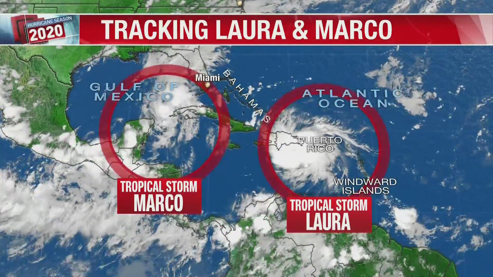
They also reported that Marco has gotten weal while Laura is going to approach Gulf by the night and will become strong after that and will turn into a hurricane on Tuesday before reaching East Texas Coastline or Mississipi river on Wednesday. Meanwhile, many forecasts have alerted of landfall near the Florida panhandle.
LOUISIANA GOVERNOR, BEL EDWARDS REQUESTED RESIDENTS TO BE PREPARED IN HIS INTERVIEW WITH ‘WWNO’:
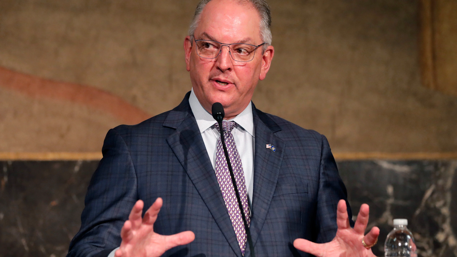
In a recent interview, the Governor of Louisiana, Bel Edwards requested residents to be prepared and do as much as they can to stay safe in a day that is left because the next day a very strong hurricane is coming their way. He also alerted residents that they should expect the storm to bring heavy rain, coastal floods, and dangerous tornadoes along with it.
He further said that these instructions are not only for the people who live in that area but also for those who live outside or around that area. He is just doing his utmost to alert people of the climatic disaster beforehand.
Edwards’ Statement:
In his interview with WWNO, Edwards made a statement saying ‘I just want everyone to be prepared of the strongest storm that is coming their way and all of you should understand this critical situation and take advantage of the day you are left with to prepare for your safety’.
WDSU, AN NBC’s AFFILIATE REPORTED:
Storm Marco hit Louisiana’s Mississipi river around 6 p.m. with 40 mph wind speed and intensity while people were already fearing the Laura storm that is about to hit them. But it is now getting weaker, reported by NBC affiliate, WDSU.
NATIONAL WEATHER SERVICE’S UPDATE ON STORM MARCO:
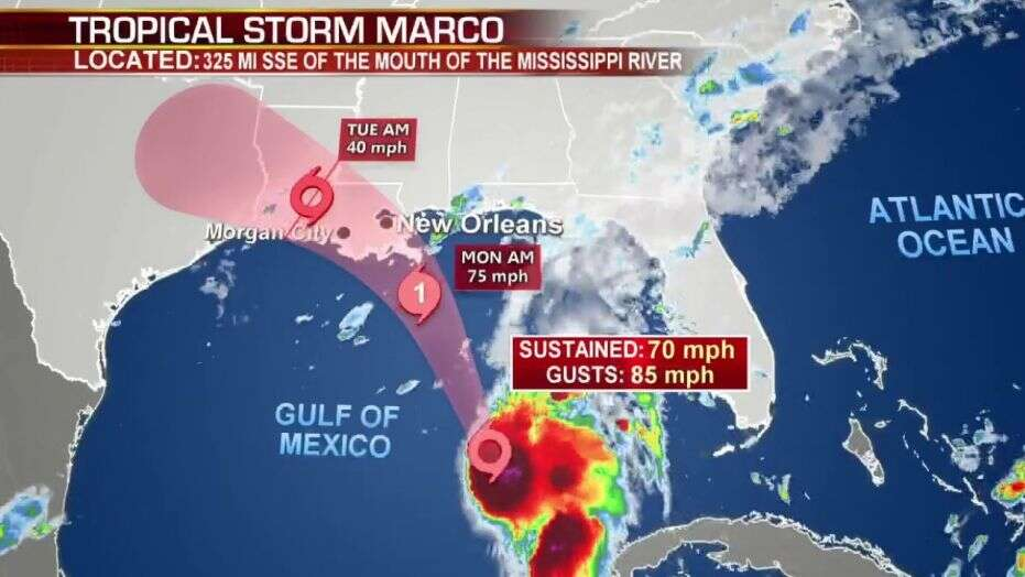
New Orleans, NWS gave an update on the latest condition and situation of the storm Marco, in which they said that the storm is more likely to hit small towns with more intensity but when it will pass from there to make its way to the coast of Louisiana, it will lose its severity and intensity and intensity and will not be dangerous anymore.
They also reported that heavy resin is expected in the areas of the North-Central Gulf on Monday night so people should be prepared for any type of situation and should try to protect themselves.
KEN GRAHAM, NATIONAL HURRICANE CENTER DIRECTOR TALKS ABOUT THE STORM IN A PRESS BRIEFING:
Earlier today, the director of National Hurricane Center, Ken Graham told in a press briefing that Storm expected to become stronger after passing the waters of Gulf because it is suspected to pick power from the gulf water which will make it even stronger than before.
Furthermore, he said that Laura will bring flood in many areas of Louisiana, according to the new forecast, as Marco did in the previous week but it wasn’t on a large scale.
Most of the area of Florida panhandle, Georgia, and Southern Alabama is already drenched by the Marco. Storm Marco brought about 8-9 inches of rain in these areas and is expected to follow the same pattern on reaching Louisiana and Texas. While the Storm laura is expected to bring 4-8 inches of rain across the West-Central U.S. Gulf Coast, near the Texas and Louisiana border.
TROPICAL STORM LAURA’S PREDICTED IMPACT IN THE U.S.:
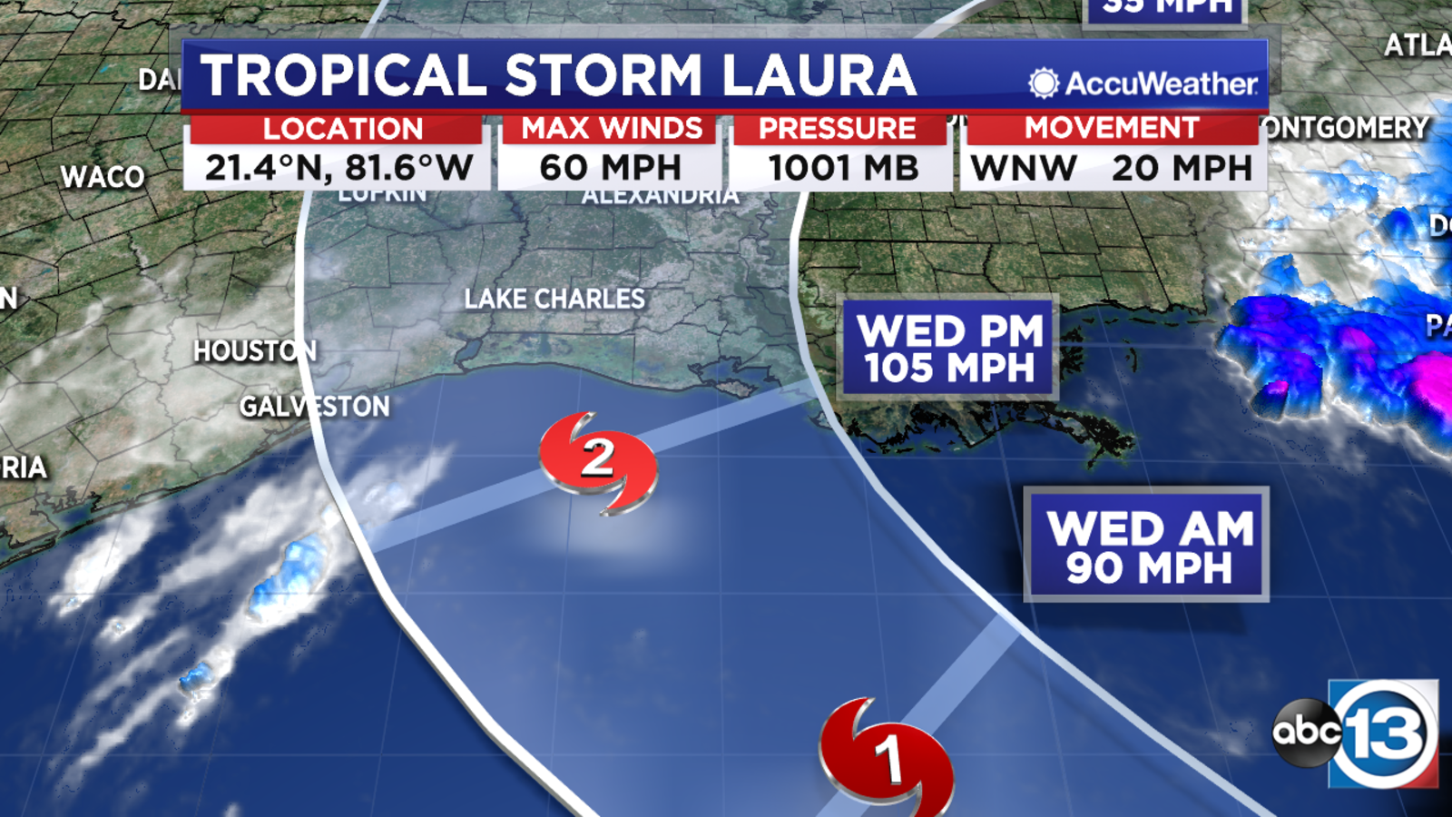
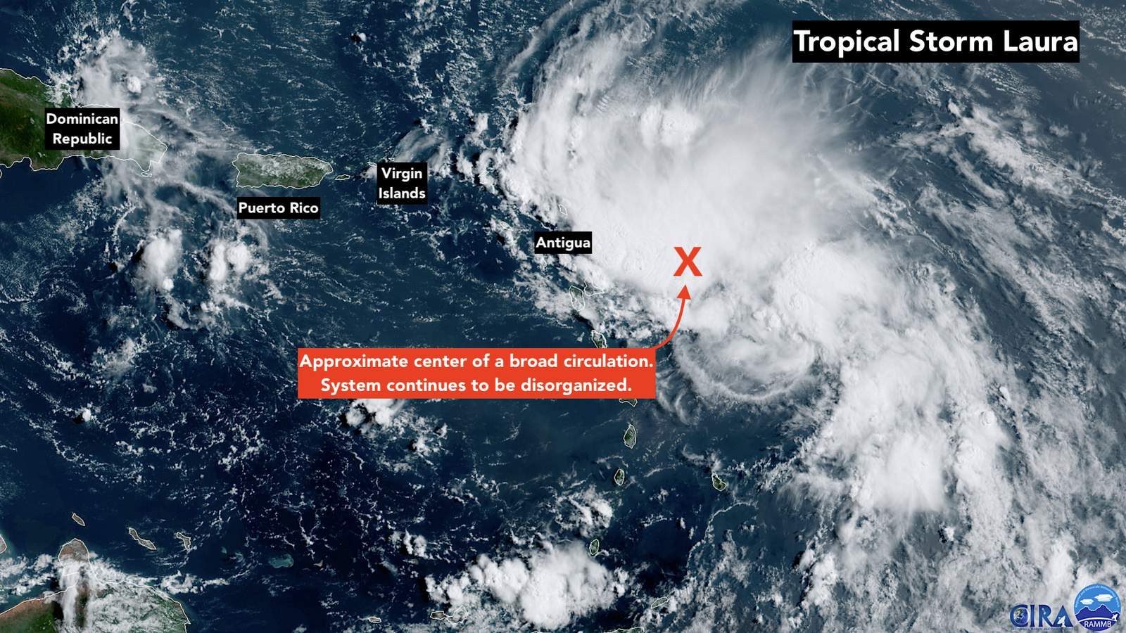
According to the latest forecast reports, Laura is entering Cuba and is about to hit the hottest waters of Cuba, which will make it more powerful. The storm already had 65 mph wind speed, and according to the findings, it will hit Texas and Louisiana as a hurricane of 110 mph.
Federal Forecasters’ Update:
Federal forecasters released a new update saying that storm Laura is suspected to be the strongest and show its true colors starting from Wednesday till Friday, and due to its powerful nature, it can result in flooding many areas as well as streams and rivers. The areas, Laura is expected to pass through include Florida keys, Cuba, Craig Key to Key West, Cayman Islands, and will spread to the west in the Dry Tortugas National Park.
HURRICANE CENTER’S EARLY WARNING ON STORM MARCO:
According to all the reports released earlier on Sunday, Hurricane Center said that Marco is approaching and there is big a threat due to the heavy rainfall it can bring with it which will result in 2-4 inches of accumulations in areas of northeast and North-Central Gulf Coast, on Tuesday.
But later on, on Monday, the Hurricane Center rejected all the previous news about the storm Marco saying that it is becoming weak with every passing day and is not dangerous anymore. This news was a big relief for the residents who were in fear because they were told that Marco can bring 2-4 feet of the coastal flood, in Louisiana and Mississipi.
Another downside of this situation is that that country is already going through a pandemic, Coronavirus, so there are not enough resources and space to deal with another disastrous situation like this.
EDWARDS ADDRESSED THE RESIDENTS OF LOUISIANA AND MISSISSIPI, ON SUNDAY:
The Governor of Louisiana, Edwards spoke to the residents saying that ‘they are on their own for the first 72-hours, because this storm came right after the other one and they do not have enough helicopter and resources, for now, to rescue that much people so just try to help yourself and look out for others as much as you can until we arrange the stuff to rescue people. It would be of great help to you and us as well’.
These severe climate changes are predicted to be the result of an increasing number of hurricanes in the Atlantic and are creating more destruction every day.